Geological & Seismic Hazard
Geological Hazards
The main task of the Geological Department is the evaluation of the geological hazards, which constitute extreme natural events in the earth's crust, where in most cases they are accompanied by severe consequences for people's lives and their properties.
Geological hazards include earthquakes, volcanoes, mass movements, erosion, sands liquefaction and subsidence, which have been and are a disturbing problem for people's lives and their economy.
The evaluation and monitoring of such geological phenomena is aimed at reducing the risk. The study of l mass movements, erosion, sands liquefaction and subsidence, constitutes one of the main challenges of the Department of Geology, because the consequences caused by their occurrence have been among the most severe in Albania. Therefore, their evaluation is one of the most important studies that is done for the planning and development of the territory. For this purpose, complex detailed studies are required, such as engineering geology, geologic-tectonic and hydrogeologic mapping and geophysical investigation as well, to distinguish areas with risk degree classified in areas with i). no risk, ii). very low, iii). low, iv). average, v). high and vi). very high.
Furthermore, the assessment of the stability of hill and mountain slopes and the occurrence of landslides at the Institute of Geosciences are using modern methods such as the GPS monitoring network and satellite images, etc.
Seismic Hazard
The Seismic Hazard of Albania is the product of several years of work carried out in the Department of Seismology (in the former Institute of Geosciences, Energy, Water and Environment - IGJEUM, currently the Institute of Geosciences - IGJEO, a main research unit of the Polytechnic University of Tirana).
In the current version, officially presented based on the approval at the Department meeting on January 29, 2021, the results of the follow-up studies carried out within the NATO project "SPS 984374", 2012-2015 with the topic "Improvements of Maps of Harmonized Seismic Risk of the countries of the Western Balkans", are included and re-evaluated.
Participant in the BSHAP project and co-author of the Probabilistic Seismic Risk study for Albania: Prof. N. Kuka (Project Manager and Author), Prof. Ll. Duni, Prof. Acos. R. Koçi, Dr. E. Dushi, Dr. E. Begu and Msc. St. Bozo (Participant in the project and co-author).
The seismic hazard maps formulated through the probabilistic methodology within the aforementioned project were reworked in the period January-March 2020 (Author: Prof. Neki Kuka).
In the official version, two new models of ground motion prediction equations (GMPEs), have been applied. Data analysis in the period January-March 2020 was carried out with the NSHM2014r software package (https://github.com/usgs/nshmp-haz-fortran/), of the US Geological Survey, used to generate the updated maps (2014 ) of the National Seismic Hazard Models (NSHM), for the USA (http://pubs.usgs.gov/of/2014/1091/).
Click here for more ( PDF | 1.34MB )
Methodology of Probabilistic Seismic Hazard applied for Albania
(Paper under publication @ AJNTS : the Albanian journal of natural & technical sciences
Author:Academy of Sciences of Albania (www.akad.gov.al )
OCLC Number / Unique Identifier: 718281982
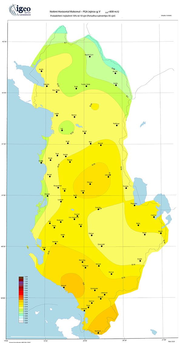
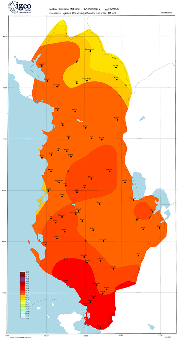
Probabilistic Seismic Hazard of Albania within the National Seismic Risk Assessment, as support to the legal acts in power and the National Agency for Civil Protection (NACP) activities.
In order to support the inpower legislation, namely CMV No. 1162, date 24/12/2020, “On the procedures and timeline to obtain the Risk Certificate of the Subjects which requires to be certified with construction/develomend permission”, based on up to date official results of the Seismic Hazard assessments for Albania (The probabilistic seismic hazard maps for the probability level 10% exidance in 50y and 10% exidance in 10y respecrively, meeting the standards and technical requirements of the Albanian state legislation and the Eurocode 8 (EN1998-1) provissions, IGEO:
- Recomend for the construnction purposes within the Albanian territory the Probabilistic Seismic Hazard Maps 2021, namely meeting the 10% exidance probabbility in 50 y (475y Return Period -TR) and 10% exidance probability in 10 y (95 y Return Period -TR), as published on IGEO web. These maps will be in use up to their update within the international collaboration project with Global Earthquake Model (GEM).
- Recomend for the construnction purposes within the Albanian territory on the application of provissions stated by CMV No. 1162, date 24/12/2020, seismic hazard values in terms of PGA for 95y and 475y TR respectively, assessed for each of the Municipalities and Administrative Units in the country. These values represent agR parameter as defined in the Eurocode 8 provissions standards.
- Recomend as reference horizontal and vertical elastic spectra, for the entire territory of the contry, the standard spectral shapes of Type 1, as defined in the Eurocode 8, scaled by the respective values of the local seismic hazard, refering both levels of damage and selected on the bases of soil conditions based on direct and indirect onsite measurements, according to the recommendations of the national legislation and Eurocode 8 provission standards.
Download PGA by Administrative Units ( PDF | 1.76MB )